The Skinny
- What: Pictured Rocks National Lakeshore, 1505 Sand Point Rd, Munising, MI 49862. (906) 387-3700. Admission is $15, camping is $25 per night. Open 24 hours.
- How To Get There: Our preferred ride in is from the south on Wisconsin Highway 35 to U.S. Route 41, which is a scenic ride along Green Bay and Lake Superior into the Hiawatha National Forest, and then Michigan Highway M-94 to Munising.
- Best Kept Secret: The pasties, at any of several locations in Munising.
- Don’t Miss: The autumn riding, as the colors are amazing, and Muldoon’s for pasties.
Picture Rocks National Lakeshore, Michigan
Pictured Rocks National Lakeshore, part of the National Park Service network and the country’s first designated national lakeshore, is in Michigan’s Upper Peninsula on the shores of Lake Superior. Consisting of deep forests, lakes, towering shoreline sandstone formations, sandstone cliffs, beaches, and sand dunes, Pictured Rocks National Lakeshore is 42 miles long. The 1820 Lewis Cass expedition first surveyed this region and the western portions of Michigan Territory; prior to that, the area had been settled for centuries by Native Americans, explorers, and fur traders. Industrial logging started in 1877 and continued unabated until the area’s pine forests were depleted. Conservation efforts replaced pine with hardwood trees which ultimately aided tourism; more on that in a moment.
The Upper Peninsula’s local town, Munising (pronounced “muni sing”) became a lumber, railroad tie, paper, and cardboard center. At one point, Munising produced 70 tons of paper daily. Kimberly-Clark purchased the local production facilities in 1952. A tourism boom, driven by a burgeoning national appetite for travel, started in the 1950s. Tourism eclipsed lumber and paper as the region’s dominant industry. The federal government designated Pictured Rocks National Lakeshore part of the National Park System on October 15, 1966.
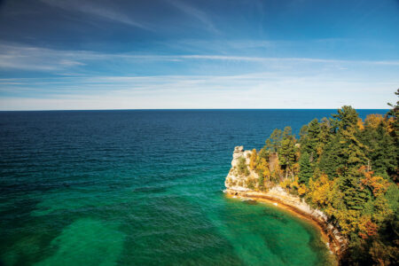
The establishment of Pictured Rocks National Lakeshore helped make access to the shoreline rock formations easier, although it still is not easy. Once we entered Pictured Rocks National Lakeshore, we found that it is not like the Jersey shore or the Grand Canyon’s South Rim; we could not simply ride along Lake Superior’s shoreline and take in the majestic sandstone cliffs and vibrant green waters. Reaching the sandstone formations involves taking different roads to each, with separate roads ending at Lake Superior’s edge. Regarding the aforementioned deforestation: You would not know it to ride through the area. The area is heavily forested as a result of the lumber industry replacing pine with hardwood species, and in the fall, those roads and the leaves turning colors make for a beautiful ride. It is a magnificent area well suited for exploration on nearly any kind of motorcycle in the summer months (it is colder in the fall, and much colder in the winter). As the autumn color displays hint, the temperatures at night and in the early morning hours are brisk; we had frost on the windshield in the morning.
Pictured Rocks lives up to its name, and our ride up there from Green Bay, Wisconsin, was thoroughly enjoyable. Once we left the freeway, the roads were scenic and we were there at exactly the right time: mid-October, when the leaves were turning colors. Every scene and our entire ride at that time of year appear as if the Almighty cranked up the saturation in a photo editing program. The roads are all fairly straight with few curves, and the speed limits are modest. The highest we saw was 55mph and many areas were 40 or 45mph. A big touring bike like a Harley or a Gold Wing would be fine, as would a smaller displacement street or trail bike.
We spent one night in Munising, and we could not get anyone to recommend a restaurant, and after trying one, we understood why. Pasties (filled pastries) are a viable meal alternative; several shops in town sell them and they are delicious.


